
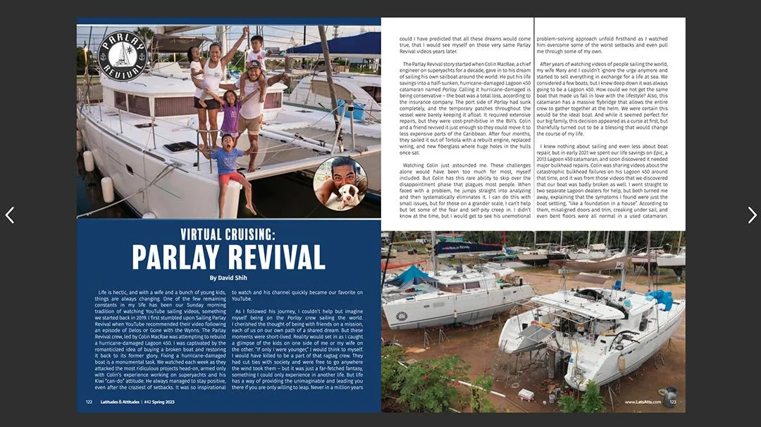
A Primer of Celestial Navigation
By Capt. Jeff Werner
Over the past thousand-plus years, instruments and techniques for celestial navigation were developed to find the latitude and longitude of any place on Earth. From the Arabian caravan navigator who used the kamal to guide his camels across the desert to the bazaars in Timbuktu, to the quadrant and astrolabe that Christopher Columbus used on his voyage of discovery in 1492. Running down the latitude and taking lunar distances to determine longitude were practical techniques for navigators at sea until 1850. Today, cruising sailors can use a modern marine sextant and the Marcq Saint-Hilaire (or altitude intercept method) method developed in 1875. Regardless of the instruments and techniques used throughout the ages, there is one constant: It’s all about altitude!
What Is Celestial Navigation?
-Taking a sight with a sextant to measure the angle above the horizon of the Sun, Moon, planets, or stars.
- Reducing that sight using a nautical almanac and complex spherical trigonometry formulas.
- Or even easier, reducing that sight with sight reduction tables or sight reduction software to plot a line of position (LOP).
- It is used to navigate on the open sea greater than 50 nautical miles from shore, or coastwise offshore.
The Key to Celestial Navigation:
- Determining the distance and direction from a point directly under a celestial body, known as the geographic position (GP), to where your yacht is at sea to draw an LOP.
Finding your Latitude & Longitude:
- One LOP does not give a fix.
- Two LOPs or a running fix gives a good fix.
- Three LOPs give the best fix.
- These are the exact same rules used in coastal navigation with a hand-bearing compass.
Tools Needed:
- Sextant for measuring the altitude of celestial objects.
- Chronometer or watch for timekeeping when measuring the altitude of celestial objects.
- Notebook for recording altitudes of observed celestial objects.
- Sight reduction forms, which are templates for finding an LOP of celestial objects, latitude from a noon sight of the Sun, or latitude from a sight of Polaris.
- Nautical almanac for the GP of observed celestial bodies for every second of the year.
- Sight reduction tables for spherical trigonometry solutions to the navigational triangle in a look-up table format. This format is similar to printed telephone directories of years past.
- Universal plotting sheets (UPS) to create a “local” chart to plot LOPs to obtain a fix.
- Parallel ruler, square protractor, and dividers for plotting on a UPS - Pencil and a big eraser.
Modern Marine Sextant:
- Is a double-reflecting altitude measuring instrument.
- It has an arc of 60° in length or 1/6 of a circle, hence the name “sext”-ant.
- It measures angles from 0 to 120°.
- For celestial navigation purposes, the sextant only needs to be able to measure altitude to the zenith or 90°.
- The ability to measure up to 120° allows the sextant to use horizontal angles to determine a vessel’s location when close to shore using a technique similar to that of a hand-bearing compass to complete a three-point fix.
The choice of a sextant to purchase is fairly simple. When learning how to take sight of celestial objects, use a plastic sextant such as the Davis Mark 15. For under $200, you have an instrument, with practice, that will give you celestial fixes accurate to within five miles of a GPS fix. Once you are comfortable that you have mastered your sextant rocking technique, it’s time to graduate to a metal sextant. And you can stow your plastic sextant in your ditch bag for emergencies.
Jeff Werner has been a yacht captain for more than 30 years. He is a certified instructor for U.S. Sailing and the RYA. Jeff is a U.S. Sailing celestial navigation instructor and has completed over 100,000 miles of passage making under sail.
Subscriptions we offer
For Only $14.99/year you can have Digital access to all the great Lats & Atts articles including past issues, downloading for offline viewing; VIP Party Invites, Discounts on Gear/Apparel and more.
LIVE YOUR DREAM
SEE ALL SUBSCRIPTION OPTIONS
Join over 50,000 Readers Who Love The Cruising Lifestyle with a Print* or Digital Subscription.

FREE
For 30 Days
& $14.99 per year after
Access to current issue for 30 days
Access to exclusive video content
Discounts on Gear/Apparel at the Lats & Atts Store
Cancel anytime
Like what you read and want to continue? $14.99 will be billed to your card after your 30-day trial for 1 FULL YEAR of new issues and all the back issues you can handle!
$14.99
YEARLY
Access to 4 issues of the Digital Magazine
Discounts on Gear/Apparel at the Lats & Atts Store
Invitation to our exclusive Lats & Atts subscriber party in Annapolis
$29.99
YEARLY
4 issues of Latitudes & Attitudes mailed directly to your house
1-year Digital Magazine Access
Invitation to our exclusive Lats & Atts subscriber party in Annapolis
$39.99
YEARLY
4 issues of Latitudes & Attitudes mailed directly to your house
1-year Digital Magazine Access
Invitation to our exclusive Lats & Atts subscriber party in Annapolis
$59.99
YEARLY
4 issues of Latitudes & Attitudes mailed directly to your house
1-year Digital Magazine Access
Invitation to our exclusive Lats & Atts subscriber party in Annapolis
Already a Lats & Atts Subscriber? Click HERE to
access your digital subscription.
© 2023 Latitudes & Attitudes - All Rights Reserved